
Mitchel Airfield: Long Island&rquo;s Forgotten Air Force Base
Robert G. Waldvogel
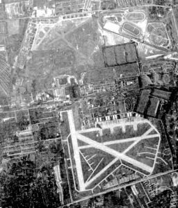
During WWII, a fourth paved runway was added along with hard stands for aircraft dispersal. This 1948 photo shows Mitchell Field in pretty much its final configuration. Roosevelt Field can be seen just ot the north, illustrating the close proximity of the two airports. (USAF photo)
Mitchel Airfield: Long Island’s Forgotten Air Force Base
Students changing buildings at Hofstra University and Nassau Community College on Long Island are most likely oblivious to the fact that they are walking on areas that were once occupied by taxiways and runways. To which airport they belonged is either equally elusive to determine or altogether forgotten. But the two hangars which are now part of the nearby Cradle of Aviation Museum and house some 70 historic aircraft, may provide a clue. “Mitchel Field,†they indicate. But where exactly did this “field†go?
Early Area History
Military in purpose, Mitchel Field was located in an area originally designated the "Hempstead Plains" and became the latest in a line of such military installations.
"Most of the aviation activities on Long Island centered around the skies of the Hempstead Plains,†according to Reggie Shore in his article, “Mitchel Field and the History of Aviation on Long Island". The Hempstead Plains, a 60,000-acre area in the center of Nassau County, is the easternmost native grassland in North America and somewhat of a mystery because it cannot be explained by its geological foundation.
Devoid of trees and shrubs, it was an untouched expanse of grassland and with its obstruction-less characteristics, was conducive to flying during the early part of the 20th century.
"Scientists speculate that the presence of so much grass with so few other plants was caused by the Indians, who might have burned the land as an aid to hunting or farming," Shore continues.
While trees failed to rise from this flat field, airplanes eventually did from one designated "Mitchel," but the military purposes the area had previously served were many.
During the Revolutionary War, for example, the 17th Light Dragoons of the British Army were stationed there and an Army enlistment center also took root. During the War of 1812 and the Mexican War, it became an infantry training post named Camp Black. During the Civil War, it served as that conflict’s base under the name of Camp Wilfred Scott. And during World War I, it became Camp Mills, and the 42nd (Rainbow) Division, which included the Fighting 69th Regiment, trained there.
"Camp Mills, an area of 913 acres lying just west of Mitchel Air Force Base, was the largest center of the American Expeditionary Forces during World War I, with some 80,000 men under canvas and in barracks during the period,†advises Elizabeth Brown in the “Historic Michel Field".
The facility, initially known simply as "Hazelhusrt Aviation Field Number 2," was leased by the government a year earlier, on July 1, 1917, from the Hempstead Plains Company.
Finally, the area was designated Michel Field on July 16, 1918, after New York City’s youngest mayor, John Purroy Mitchel, who was killed in a Signal Corps Army Air Service . . .
This article costs $5.00 to download - or it's free for AAHS members.
Already a member? Sign in to download for free.